
File:Land ocean ice cloud hires.jpg

File originale (8 192 × 4 096 pixel, dimensione del file: 9,77 MB, tipo MIME: image/jpeg)
| Questo file e la sua pagina di descrizione (discussione · modifica) si trovano su Wikimedia Commons (?) |
Dettagli
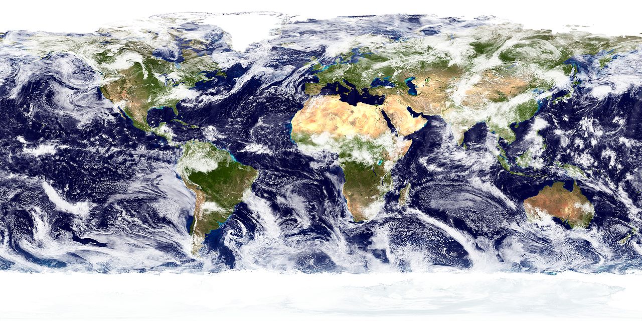
Land surface, ocean color, sea ice and clouds. High resolution, 8192 x 4096. Compressed into JPEG at 90% quality.
From the website [1]:
"This spectacular “blue marble” image is the most detailed true-color image of the entire Earth to date. Using a collection of satellite-based observations, scientists and visualizers stitched together months of observations of the land surface, oceans, sea ice, and clouds into a seamless, true-color mosaic of every square kilometer (.386 square mile) of our planet. These images are freely available to educators, scientists, museums, and the public. This record includes preview images and links to full resolution versions up to 21,600 pixels across.
Much of the information contained in this image came from a single remote-sensing device-NASA’s Moderate Resolution Imaging Spectroradiometer, or MODIS. Flying over 700 km above the Earth onboard the Terra satellite, MODIS provides an integrated tool for observing a variety of terrestrial, oceanic, and atmospheric features of the Earth. The land and coastal ocean portions of these images are based on surface observations collected from June through September 2001 and combined, or composited, every eight days to compensate for clouds that might block the sensor’s view of the surface on any single day. Two different types of ocean data were used in these images: shallow water true color data, and global ocean color (or chlorophyll) data. Topographic shading is based on the GTOPO 30 elevation dataset compiled by the U.S. Geological Survey’s EROS Data Center. MODIS observations of polar sea ice were combined with observations of Antarctica made by the National Oceanic and Atmospheric Administration’s AVHRR sensor—the Advanced Very High Resolution Radiometer. The cloud image is a composite of two days of imagery collected in visible light wavelengths and a third day of thermal infra-red imagery over the poles. Global city lights, derived from 9 months of observations from the Defense Meteorological Satellite Program, are superimposed on a darkened land surface map."
من الموقع [2]:
"" "هذه الصورة المذهلة" للرخام الأزرق "هي الصورة الحقيقية ذات الألوان الحقيقية الأكثر تفصيلاً لكامل الأرض حتى الآن. وباستخدام مجموعة من الملاحظات المستندة إلى الأقمار الصناعية ، قام العلماء والمتخيلون بتجميع شهور من الملاحظات على سطح الأرض والمحيطات والبحر الجليد والسحب في صورة فسيفساء سلسة بألوان حقيقية لكل كيلومتر مربع (386 ميل مربع) من كوكبنا. هذه الصور متاحة مجانًا للمعلمين والعلماء والمتاحف والجمهور. يتضمن هذا السجل صور معاينة وروابط إلى إصدارات كاملة الدقة تصل إلى 21600 بكسل.
الكثير من المعلومات الواردة في هذه الصورة جاءت من جهاز واحد للاستشعار عن بعد - مقياس طيف التصوير متوسط الدقة التابع لوكالة ناسا ، أو MODIS. تحلق فوق 700 كيلومتر فوق الأرض على متن القمر الصناعي Terra ، وتوفر MODIS أداة متكاملة لرصد مجموعة متنوعة من السمات الأرضية والمحيطية والجوية للأرض. تستند أجزاء اليابسة والمحيط الساحلي من هذه الصور إلى الملاحظات السطحية التي تم جمعها من يونيو حتى سبتمبر 2001 ومجتمعة ، أو مركبة ، كل ثمانية أيام للتعويض عن السحب التي قد تمنع رؤية المستشعر للسطح في أي يوم. تم استخدام نوعين مختلفين من بيانات المحيطات في هذه الصور: بيانات الألوان الحقيقية للمياه الضحلة ، وبيانات لون المحيطات العالمية (أو الكلوروفيل). يعتمد التظليل الطبوغرافي على مجموعة بيانات الارتفاع GTOPO 30 التي تم تجميعها بواسطة مركز بيانات EROS التابع للمسح الجيولوجي الأمريكي. تم دمج ملاحظات MODIS للجليد البحري القطبي مع ملاحظات القارة القطبية الجنوبية بواسطة مستشعر AVHRR التابع للإدارة الوطنية للمحيطات والغلاف الجوي - مقياس الإشعاع المتقدم عالي الدقة. الصورة السحابية مركبة من يومين من الصور التي تم جمعها في أطوال موجات الضوء المرئي ويوم ثالث من الصور الحرارية بالأشعة تحت الحمراء فوق القطبين. أضواء المدينة العالمية ، المستمدة من 9 أشهر من الملاحظات من برنامج الأقمار الصناعية للأرصاد الجوية الدفاعية ، متراكبة على خريطة سطح أرض مظلمة. "Credit:
NASA Goddard Space Flight Center Image by Reto Stöckli (land surface, shallow water, clouds). Enhancements by Robert Simmon (ocean color, compositing, 3D globes, animation). Data and technical support: MODIS Land Group; MODIS Science Data Support Team; MODIS Atmosphere Group; MODIS Ocean Group Additional data: USGS EROS Data Center (topography); USGS Terrestrial Remote Sensing Flagstaff Field Center (Antarctica); Defense Meteorological Satellite Program (city lights).
Licenza
| Questo file è nel pubblico dominio perché creato dalla NASA. La politica sul copyright della NASA afferma che «il materiale della NASA non è protetto da copyright a meno che non sia specificato altrimenti». (NASA copyright policy e JPL Image Use Policy). | ||
 |
Attenzione:
|
Cronologia del file
Fare clic su un gruppo data/ora per vedere il file come si presentava nel momento indicato.
| Data/Ora | Miniatura | Dimensioni | Utente | Commento | |
|---|---|---|---|---|---|
| attuale | 03:06, 27 gen 2007 | | 8 192 × 4 096 (9,77 MB) | Hymyly~commonswiki | Land surface, ocean color, sea ice and clouds. High resolution, 8192 x 4096. Compressed into JPEG at 90% quality. From the website [http://visibleearth.nasa.gov/view_rec.php?vev1id=11622]: ''"This spectacular “blue marble” image is the most detailed |
Voci che usano questa immagine
La seguente pagina usa questo file:
Utilizzo globale del file
Anche i seguenti wiki usano questo file:
- Usato nelle seguenti pagine di ar.wikipedia.org:
- جغرافيا طبيعية
- بوابة:جغرافيا
- علم المياه
- علم شكل الأرض
- علوم التربة
- علم المناخ
- جغرافيا حيوية
- صحراء ناميب
- علم المحيطات
- علم المسطحات المائية الداخلية
- علم الجليد
- مسح بحري
- علم دراسة التربة
- منطقة الحوض والسلسلة
- قالب:جغرافيا طبيعية
- علم المناخ القديم
- بوابة:جغرافيا/قوالب
- توزع الأنواع
- جبال وايت
- جغرافيا ساحلية
- جغرافيا تاريخية
- جغرافيا قديمة
- علم رباعي
- بيئة المناظر الطبيعية
- سييرا مادري الجنوبية
- رصيف البحري التحاتي
- ثقب انفجاري
- برك ذائبة
- علوم المحيطات البيولوجية
- مضيق هيكات
- مدخل ديكسون
- مضيق الملكة شارلوت
- مسار الملكة شارلوت
- الأسماء الجغرافية في كولومبيا البريطانية
- ممر ديسكفري
- جزر ديسكفري
- مضيق جونستون
- قناة لويس
- مدخل بوت
- نهر ساوثجيت
- جبل الأمل (كندا)
- نهر ألويت
- بحيرة ألويت
- جبل روبي ريد
- بحيرة ستاف
- نهر ستاف
- حديقة مقاطعة غاريبالدي
- بحيرة ويدجماونت
- بحيرة تشيكاموس
- نهر تشيكاموس
Visualizza l'utilizzo globale di questo file.